Arda (Q: "Realm") was the Quenya name for the world as a whole. Arda was created within Eä by Eru Ilúvatar. It was then shaped by the Valar, with continental masses such as Middle-earth and Aman, and oceans, like Belegaer.
Arda was the home of Elves, Men, Dwarves and other races as well as the kelvar and olvar. Some of the Ainur govern the world under Eru's mandate.
Beginnings
Arda was first brought into existence with the Music of the Ainur, for the purpose of creating a home for the Children of Ilúvatar. Ilúvatar appointed the Valar as its masters, and it was built mainly by Manwë, Aulë and Ulmo.
But even before the coming of some Ainur there were other beings inhabiting Arda, perhaps without the Ainur's involvement or knowledge. One of them was Iarwain Ben-adar and other mysterious nameless things that eventually withdrew in caves under mountains.
The Valar invented its geography, for at the time it was largely without feature and gave it symmetry and form. But then Melkor wanted Arda for himself, and the two sides engaged in the titanic First War where Arda was marred and its plan was altered.
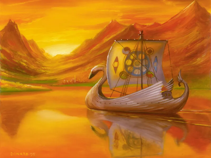
As for light source, the Valar decided upon two lamps. One, a blue light, was placed at the north, and it was called Illuin. The other, a golden light, was placed at the very southernmost point, and was called Ormal. Aulë, craftsman of the Valar, forged two pillars : Helkar and Ringil, placed at the north and south respectively. The Valar chose as their own home the green isle Almaren in the center of Arda between the two pillars.
It was at that time that Melkor made his first attempt, spreading chaos across Arda. He destroyed the Lamps and the pillars, ruining the symmetry of the world. At this time, the continents of Aman, Endor, and the Land of the Sun were formed. In the midst of Endor where the Two Lamps fell into ruin, the Sea of Helcar and the Sea of Ringil formed.
Eschatology
The Elves held to the concept of Arda Marred. In the beginning, at the time of the Music of the Ainur, was Arda Unmarred. According to the idea of Arda Unmarred, the world was originally "unstained" by evil. It became Arda Marred after Melkor entered and introduced chaos. They also clung to the idea that one day the world would become Arda Healed. According to this belief, Arda Healed will not come about until the Dagor Dagorath, the Last Battle.
Tengwa
Arda is also the name in Quenya of the twenty-sixth letter of the Tengwar alphabet. It is a modification of Rómen (letter 25). In written Quenya Arda is used for RD. In other modes this letter represents voiceless R (or RH). The Westron name for this letter is Rhó.
Theories
Using the known sizes of Beleriand and Middle-earth when compared to the size of Beleriand on Map V of the Ambarkanta maps, Karen Wynn Fonstad has speculated that flat Arda's diameter was probably about 6,800 miles. However, Diagram III of the Ambarkanta shows that the "Old Lands" made up half of Arda made round, implying that flat Arda would have been around 12,451 miles across, half the earth's circumference. Precise estimations of the size of Arda are difficult to determine with Map V of the Ambarkanta, which is said by Christopher Tolkien to be "a very rough sketch not to be interpreted too strictly".
Geography
Before the Shifting
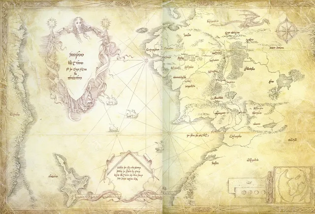
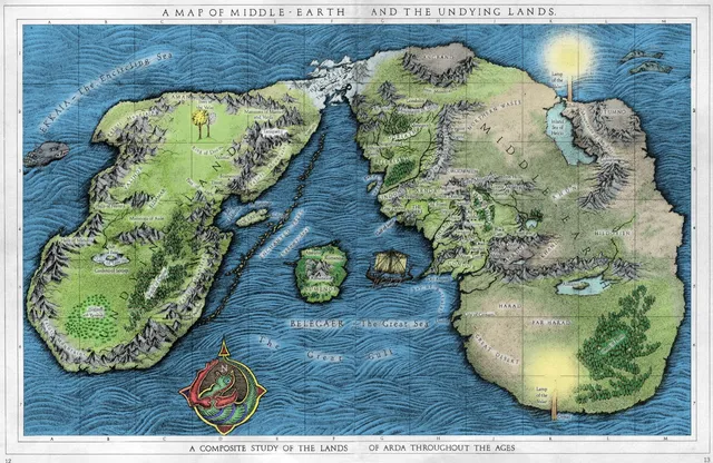
Arda was originally flat, like a plate. Encircling the continents was Ekkaia, the Encircling Sea. Farthest to the West was the great continent of Aman, composed primarily of two geographical features: the Plain of Valinor, and the Pelóri Mountains. Taniquetil was the highest mountain in this range, and in the world. Separating Aman from the lands to the east was the great sea of Belegaer.
Across Belegaer was Middle-earth, known also as Endor or the Hither Lands. The west side of this land mass was called Beleriand, the north Dor Daedeloth, and the east Palisor. According to Tolkien's earlier maps, it was in Palisor that there was the great inland Sea of Helcar, and the shores of Cuiviénen. At its farthest northwestern point, Middle-earth was joined to Aman by the Helcaraxë, a deathly cold region of grinding ice.
Middle-earth was dominated by many mountain ranges. Separating Beleriand from the inner lands of Middle-earth were the Ered Luin, the Blue Mountains. To the far east there were the Orocarni, the Red Mountains. Between the Blue Mountains and Red Mountains, Melkor had raised up the Hithaeglir, the Misty Mountains, to hinder the hunts of the Vala Oromë in Middle-earth. These three northern ranges were joined together at their northernmost ends by the Iron Mountains, raised by Melkor in the ages before the fall of the Two Lamps.
In the south of Middle-earth were the Grey Mountains, and in the southeast there were the Yellow Mountains. In the far east between the Orocarni in the north and the Yellow Mountains in the south there lay the Mountains of the Wind. However, when the Valar went to war against Melkor in the Battle of the Powers, much of Arda was changed again. The Yellow Mountains and the Mountains of the Wind were lost, and the Great Gulf formed between Beleriand and the lands to the far south. To the east, the East Sea and the Sea of Ringil joined together, dividing Middle-earth from a new continent known only as the Dark Land or the South Lands.
In its earliest days, Middle-earth was dominated by a great forest spanning from the western shores to the Misty Mountains and possibly beyond. However, this great forest dwindled throughout the ages, remaining only in the regions of the Old Forest, Fangorn Forest, Lothlórien, and Eryn Vorn. Greenwood the Great may also have been a remnant of this vast forest.
To the farthest east possible was the Uttermost East, with a great curved mountain range called the Walls of the Sun. In the Ambarkanta it is called the “Dark Land of the Sun”. Corresponding to Taniquetil was the mountain Kalormë.
Second Age and Beyond
During the tumultuous War of Wrath, the Valar broke and reshaped much of the world. The lands of Beleriand sank beneath the Great Sea in this conflict, drowning many lands west of the Blue Mountains. There were some islands that remained of the old world: Tol Fuin, Tol Morwen, and Himring. On the mainland, only the realm of Lindon survived the sinking of Beleriand. Lindon and the Blue Mountains were split in two after the conflict by the Gulf of Lune, possibly an eastward expansion of the ancient Bay of Balar. The mainlands shrank back furthest in the far north of the world, where the Icebay of Forochel was formed. To the south, the sinking of Beleriand robbed the Great Gulf of its northwestern ends, forming the Bay of Belfalas out of what remained.
After this catastrophic conflict, Ossë raised Elenna – a large, star-shaped isle – out of Belegaer, where the kingdom of Númenor would soon be settled.
The second great change was the Drowning of Númenor. In this cataclysm, the world was stretched and made into the shape of a sphere. At that time Aman and the island of Tol Eressëa were removed from the Circles of the World, and became inaccessible save by the Straight Way. It is said that new continents were made in place of the Undying Lands. Once again, the western coasts of Middle-earth changed, retreating in some places and advancing in others. It is unknown if the Uttermost East survived the Fall of Númenor.
